BACKGROUND:
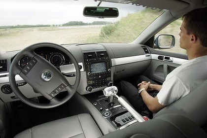
Computer scientists at Freie Universitat in Berlin, Germany, have built an autonomous mini-van called the “Spirit of Berlin,” working jointly with the Berlin Police Department.
Much like a robot, the car is completely controlled by computers, with no need for a human operator.
The car can steer, brake and accelerate, as well as turn all its components on or off, solely through its computer. However, the car can also be driven conventionally.
Future innovations will enable the car to
recognize and react to red traffic lights and traffic signs.
HOW IT WORKS:
Various sensors on the car work together to recognize pedestrians, cars, motorcycles and other road users, with the aid of
laser scanners installed on the car.
The scanners emit laser beams around the car and the light is reflected back from objects in its proximity.
The sensors measure how long it takes the reflecting laser beam to return to determine where nearby objects are located, as well as how far away they are.
Computers process all this information collected by the navigation system, laser sensors and video cameras to produce an accurate map of the mobile and immobile objects on the road.
The laser sensors’ range is 150 meters.

WHAT IS GPS?:
The Spirit of Berlin’s navigation is driven by the Global Positioning System.
GPS satellites circle the earth twice a day in a very precise orbit and transmit signal information to earth.
GPS receivers take this information and use triangulation to calculate the user's exact location.
Essentially, the GPS receiver compares the time a signal was transmitted by a satellite with the time it was received.
The time difference tells the GPS receiver how far away the satellite is.
With distance measurements from a few more satellites, the receiver can determine the user's position and display it on an electronic map.
Should the satellite signal temporarily be lost -- due to interference from a high-rise building, for example – the navigation system compensates by precisely assessing the vehicle’s position using data from gyroscopes and throttle sensors.
COMPUTERS RULE THE ROAD:
Four computers process all that data as quickly as possible.
The circuit boards receive all the data from the sensors and process it along with the GPS-position data.
The car also has video cameras mounted on the roof to further aid in determining the position of the road markings and sidewalks.
A separate computer processes the video data. Once all the data has been combined, the computer can “decide” the car’s next action.
